Two Waterfalls on the Henry's Fork
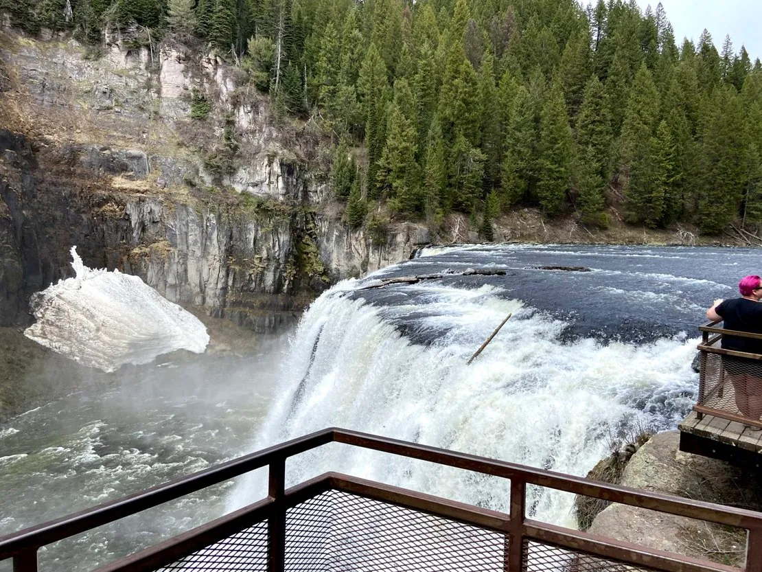
About 14 miles southeast of Island Park, the Henry's Fork of the Snake River — the same river born at Big Springs — leaves the gentle meadows of the upper basin and slams into the edge of an ancient lava flow. What follows in less than a mile is the most dramatic stretch of moving water in eastern Idaho: Upper Mesa Falls, a thundering 114-foot drop over a sheer rhyolite cliff, and Lower Mesa Falls, a 65-foot cascade hidden in a deeper canyon downstream.
What makes them remarkable isn't just the size or the spray — it's the fact that they still exist at all. Upper and Lower Mesa Falls are the last large undammed waterfalls in the entire Columbia River basin.
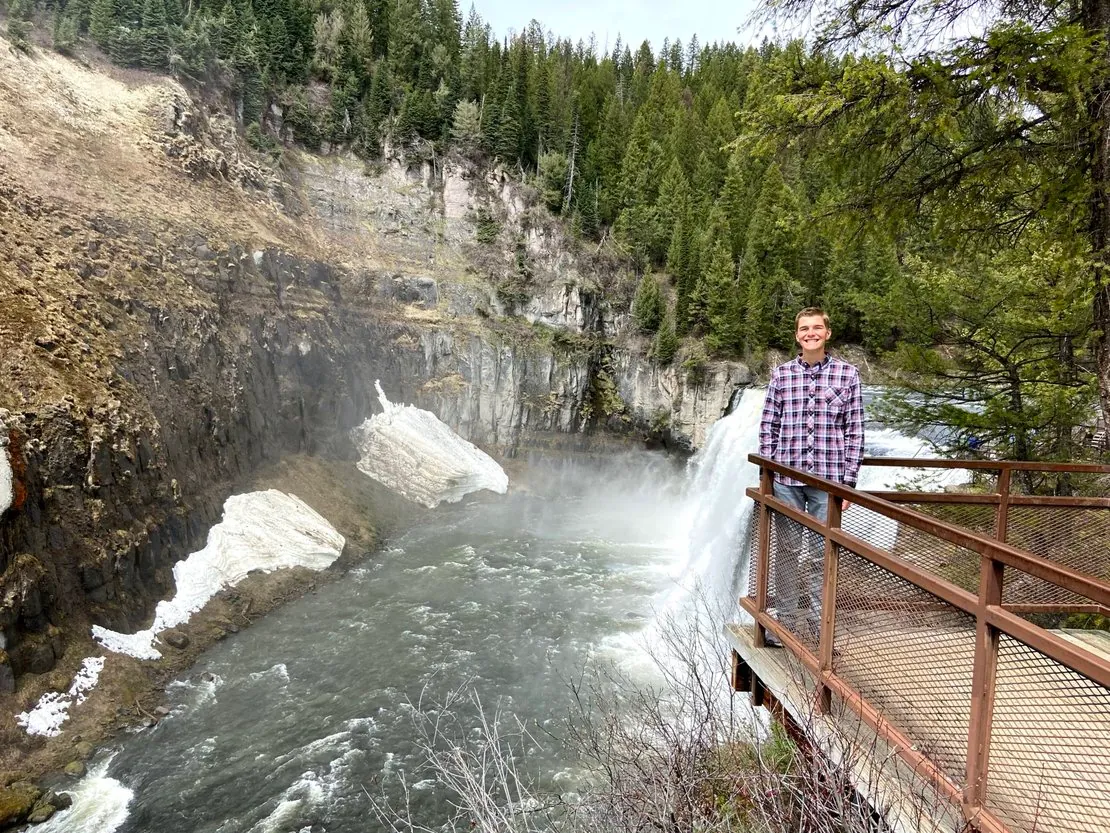
Upper Mesa Falls in spring runoff — the boardwalk gets you within feet of the brink
Geology — A Caldera's Edge
Mesa Falls exists because of one of the largest volcanic events in North American history. Roughly 1.3 million years ago, the Henry's Fork Caldera collapsed in a cataclysmic eruption that ejected an estimated 280 cubic kilometers of rock and ash. The resulting Mesa Falls Tuff — a thick, welded layer of rhyolitic ash — blanketed the landscape and, once cooled, formed the hard cliff that the Henry's Fork now plunges over. See the broader story in our companion article on the Yellowstone Supervolcano.
Native American Use of the Falls
Long before European settlers arrived, the falls and the surrounding canyon were known to the Shoshone-Bannock people, who traveled through the upper Henry's Fork drainage on seasonal hunting and fishing rounds. Lower Mesa Falls blocked salmon migration, making the stretch immediately below the falls a reliable fishery. The canyon also lay close to the route the Nez Perce traveled during their 1877 flight through Yellowstone country.
Early Settlers & The Big Falls Inn
By the 1890s, homesteaders had pushed up from the Snake River plain into the upper basin. In the early 1900s, a small wagon road was carved along the rim above the falls — the precursor to today's Mesa Falls Scenic Byway. In 1911, the Big Falls Inn was built on the rim above Upper Mesa Falls to serve travelers making the journey by stagecoach and, increasingly, by automobile.
The Mesa Falls Scenic Byway
In 1989, the road connecting Ashton to Island Park via the falls was designated the Mesa Falls Scenic Byway — one of the first such designations in Idaho. The 28-mile route winds through the Caribou-Targhee National Forest, climbing from the agricultural plains around Ashton up onto the volcanic plateau of Island Park.
Scenic Byway At-a-Glance
- • Length: 28.7 miles (Ashton to Highway 20)
- • Designation: Idaho State Scenic Byway (1989)
- • Best season: Late May through October
- • RV-friendly: Yes, paved throughout
Big Falls Inn & The Visitor Center
After decades of decline, the historic Big Falls Inn was acquired and rehabilitated by the U.S. Forest Service in partnership with private donors and local preservation groups. It reopened in the late 1990s as the Mesa Falls Visitor Center, with interpretive exhibits on the geology, wildlife, and human history of the Henry's Fork. The Inn remains on the National Register of Historic Places.
Preservation & Why the Falls Were Never Dammed
Throughout the early 20th century, nearly every other major falls in the Snake and Columbia drainages was developed. Several proposals to harness Mesa Falls were floated in the 1910s and 1920s, but each one collapsed under the weight of cost, distance from major load centers, and a growing recognition that the falls were worth more standing than spinning turbines.
Visiting Mesa Falls Today
Visiting both falls is an easy half-day from Island Park. Drive south on Highway 20 to the Mesa Falls Scenic Byway turnoff, follow the byway to the Lower Mesa Falls overlook first (a free roadside pull-out), then continue another mile to the Upper Mesa Falls Visitor Center.
Visitor Information
- • Visitor center season: Late May through mid-September
- • Day-use fee: Small per-vehicle fee at Upper Mesa Falls; Lower overlook is free
- • Distance from cabin: Approximately 30 minutes by car
- • Time needed: 1–2 hours for both falls
- • Accessibility: Boardwalks at Upper Falls are wheelchair-friendly
Always confirm current fees, hours, and seasonal closures with the Caribou-Targhee National Forest before your visit.
Winter Access by Snowmobile
The Mesa Falls Scenic Byway closes to passenger cars in winter, but the falls remain accessible by snowmobile or cross-country skis via the groomed Forest Service trail system. The frozen falls and ice formations are spectacular.
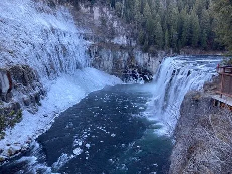
Winter at Upper Mesa Falls — accessible only by snowmobile or skis
Getting There from Our Cabin
Mesa Falls is roughly 30 minutes by car from Lodgepole Pines Retreat — one of the easiest half-day trips in Island Park. Combine it with the Harriman State Park for a full scenic day. See also our Top Things to Do in Island Park.