 (source: nps.gov)
11,000 Years of Native Knowledge
Long before any European set foot in the Yellowstone Plateau, at least 27 distinct Native American tribes had deep, multigenerational relationships with the region. The Tukudika (Sheepeaters), a band of the Eastern Shoshone, lived year-round in the mountains, hunting bighorn sheep and crafting bows from sheep horn that were prized across the Northern Plains trade networks.
The Crow, Blackfeet, Bannock, and Nez Perce all traveled through or near the plateau seasonally. Obsidian from Yellowstone's Obsidian Cliff has been found at archaeological sites across the continent — evidence of a vast trade network stretching from the Pacific Coast to the Ohio Valley that operated for thousands of years.
These peoples understood the geothermal features intimately. Hot springs were used for cooking, spiritual ceremonies, and healing. The geysers were woven into origin stories. Yellowstone wasn't a mysterious unknown — it was home.
Historical note: Early Euro-American explorers often claimed they "discovered" Yellowstone, but Native peoples had been there for at least 11,000 years. Archaeological evidence includes projectile points, fire rings, vision quest structures, and wickiup frames across the park.
To learn about how the earliest peoples used and revered this landscape, visit the Yellowstone activities page and explore the park's interpretive programs at Mammoth Hot Springs and the Old Faithful Visitor Center.
Fur Trappers & Mountain Men
The first Euro-Americans to enter the Yellowstone region were fur trappers working for companies like the American Fur Company and the Rocky Mountain Fur Company in the 1820s and 1830s. John Colter, a member of the Lewis and Clark Expedition, is widely credited as the first white man to see the geothermal features — possibly as early as 1807–1808 during a solo winter journey through the region.
Colter's descriptions of boiling springs, mud pots, and steaming ground were met with open ridicule. Newspapers mockingly called the area "Colter's Hell." The name stuck, and it took decades before anyone took the reports seriously.
Other trappers followed — Warren Angus Ferris visited the geyser basins in 1834 and left one of the earliest written accounts of a geyser eruption. Osborne Russell, a literate trapper who kept a detailed journal, described Yellowstone Lake and Lamar Valley in the 1830s with the eye of a naturalist. His Journal of a Trapper remains one of the most valuable firsthand accounts of the pre-park era.
But trappers were storytellers, not scientists. Without maps, photographs, or institutional backing, their accounts were dismissed as tall tales — or ignored entirely.
Jim Bridger — The Greatest Storyteller
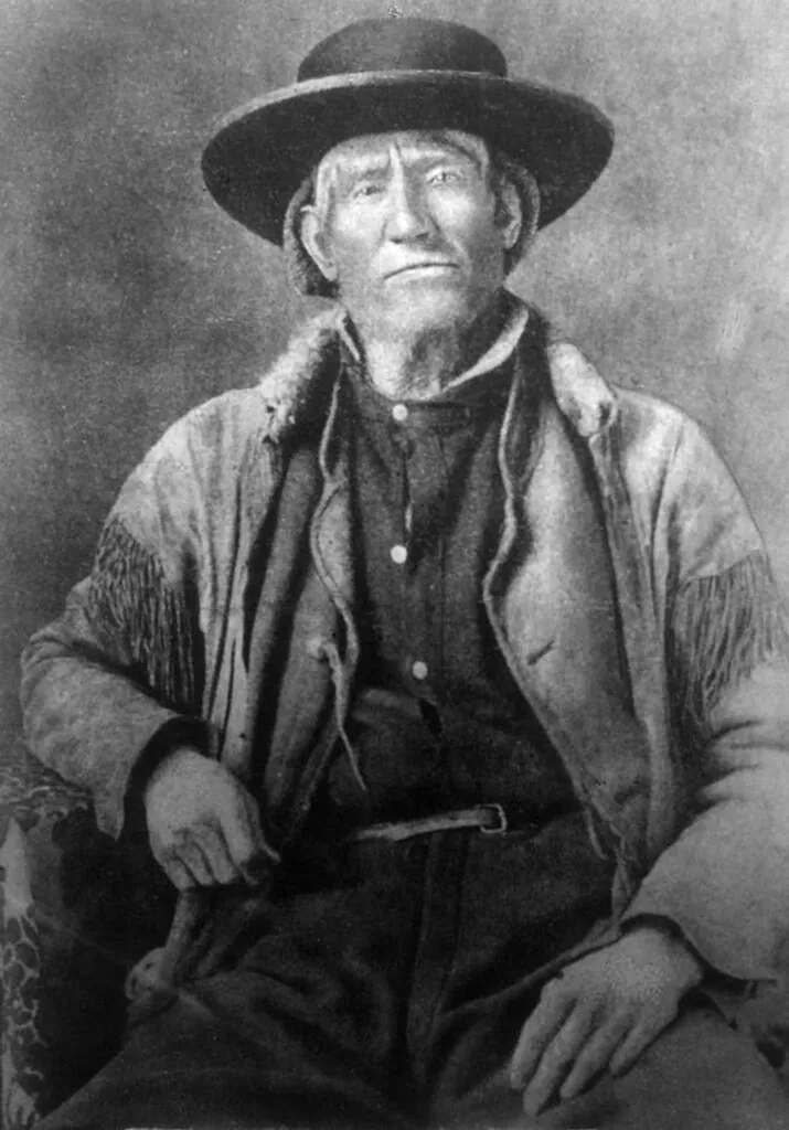
No figure looms larger in early Yellowstone lore than Jim Bridger. Born in 1804, Bridger spent over 40 years in the Rocky Mountains and became one of the most accomplished guides, scouts, and wilderness travelers in American history.
Bridger told stories about Yellowstone that blended fact and fiction so seamlessly that listeners couldn't tell where one ended and the other began. He described a mountain made of glass (Obsidian Cliff — real), a place where you could catch a fish in a cold stream and cook it in a hot spring without removing it from the line (Fishing Cone at Yellowstone Lake — also real), and a petrified forest where petrified birds sang petrified songs (an obvious embellishment of the actual petrified trees in the Lamar Valley).
The problem was that Bridger was such a gifted storyteller that people assumed everything was fiction. His accurate geographic descriptions of the Yellowstone Plateau were lumped in with his tall tales and dismissed by the scientific establishment.
It wasn't until organized expeditions arrived decades later that the scientific community realized Bridger had been telling the truth all along — at least about the geysers, the glass mountain, and the boiling rivers.
The Folsom-Cook Expedition (1869)
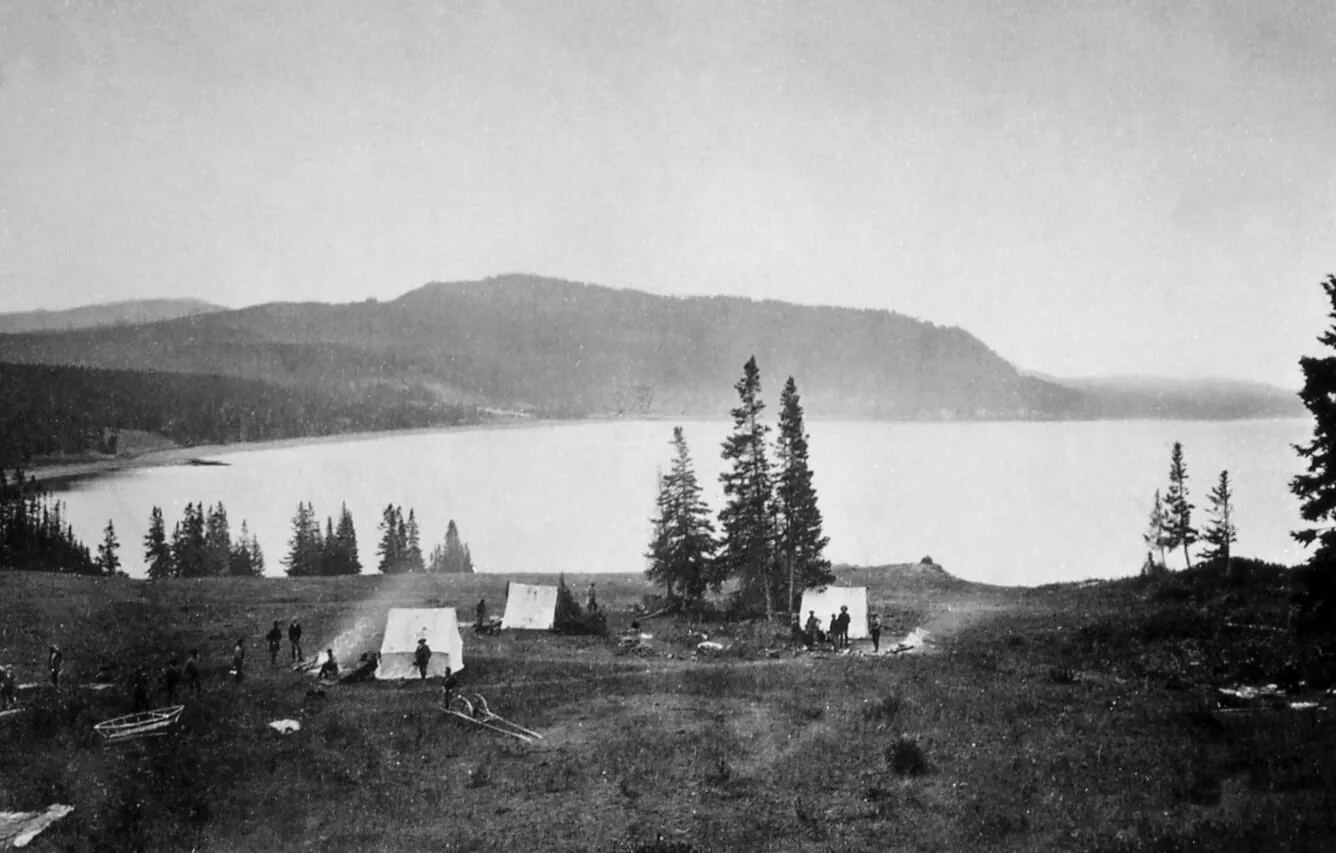
The first organized exploration of Yellowstone was the three-man Folsom-Cook-Peterson expedition of 1869. David Folsom, Charles Cook, and William Peterson — all Montana residents — spent 36 days exploring the Yellowstone Plateau on horseback.
They followed the Yellowstone River south, witnessed the Grand Canyon of the Yellowstone and its thundering falls, explored the geyser basins along the Firehole River, and circled Yellowstone Lake. Folsom kept a detailed journal that remains one of the most vivid early accounts of the park's features.
When they returned to Helena, Montana, Folsom tried to publish his account in The New York Tribune and Scribner's Monthly — both rejected it as too fantastical to be true. The Western Monthly Magazine finally published a toned-down version in 1870, but it reached a limited audience.
Despite the lukewarm reception, the Folsom-Cook expedition was pivotal. It directly inspired the much larger Washburn-Langford expedition the following year — and set in motion the chain of events that would lead to the park's creation. You can read about that watershed moment in our article on the creation of Yellowstone National Park.
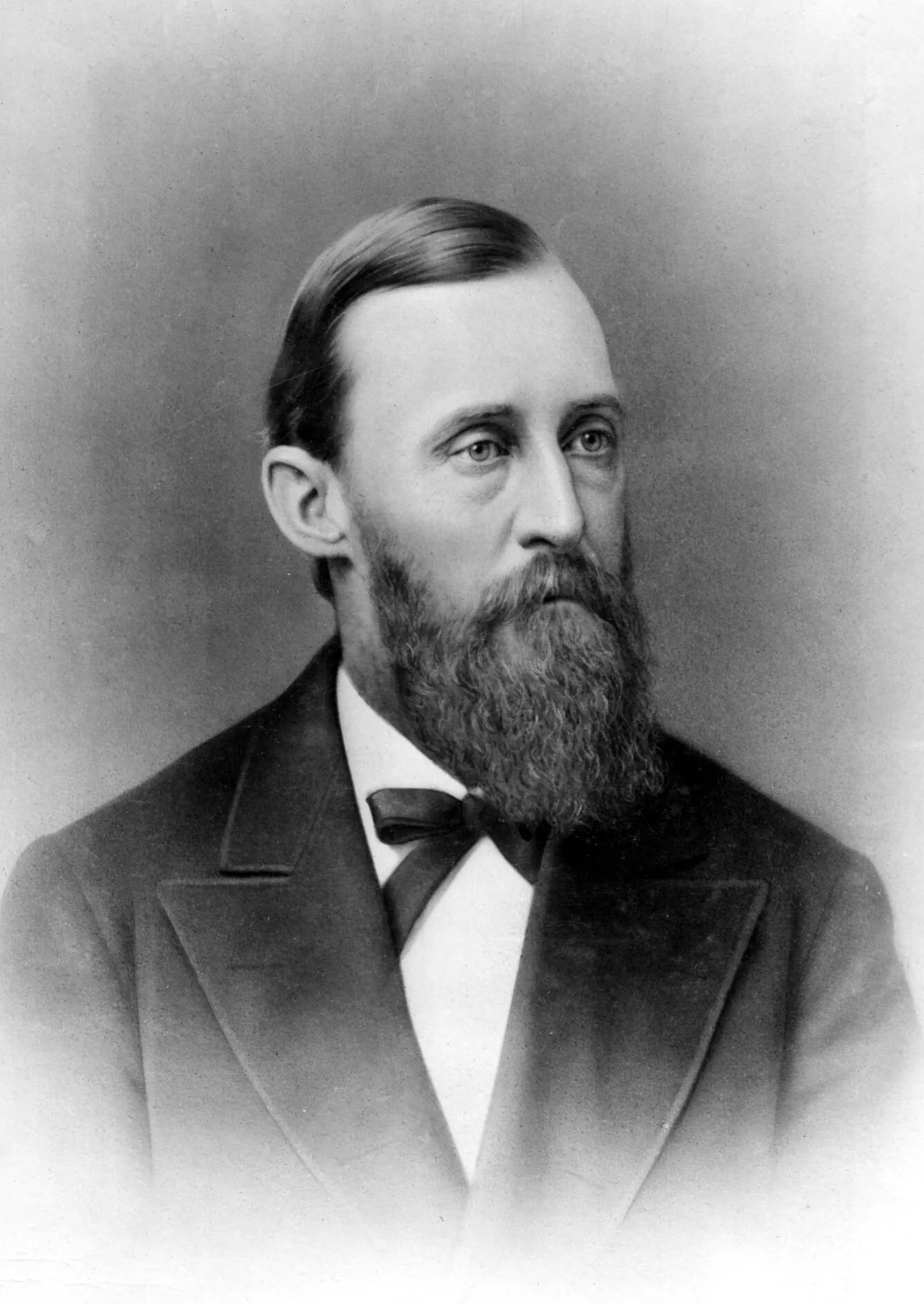
The Washburn-Langford Expedition (1870)
Inspired by Folsom's accounts, Henry Dana Washburn (Surveyor General of Montana Territory) organized a 19-member expedition in August 1870 with a military escort led by Lieutenant Gustavus Doane. The group included Nathaniel Pitt Langford, who would later become the park's first superintendent, and Cornelius Hedges, a Helena attorney.
The expedition spent a month exploring the plateau. They named many of the park's most iconic features — including Old Faithful, which they witnessed erupting with clockwork regularity. They explored Tower Fall, Mount Washburn, the Grand Canyon, Yellowstone Lake, and the Upper and Lower Geyser Basins.
The expedition also produced the famous "campfire story" — the oft-repeated (and likely embellished) tale that members gathered around a campfire at the junction of the Firehole and Gibbon Rivers and agreed the area should be preserved as a public park rather than divided into private claims. Whether the conversation happened exactly as described is debated, but the sentiment was real.
Langford went on a national lecture tour and published detailed accounts in Scribner's Monthly. This time, people listened. His vivid descriptions reached Ferdinand V. Hayden, the head of the U.S. Geological Survey, who immediately began planning a government-funded scientific expedition.
To see the geysers and canyons they named, explore our Famous Geysers of Yellowstone guide and our Best Things to Do in Yellowstone itinerary.
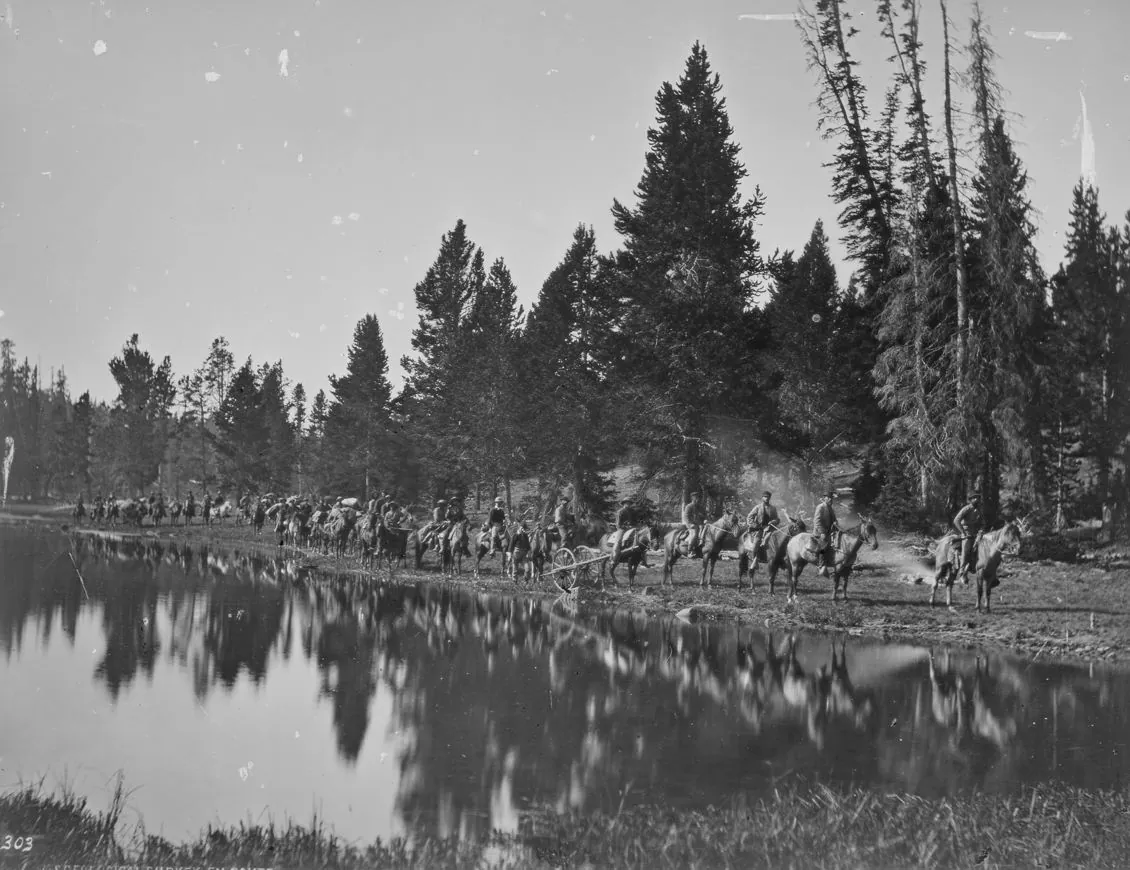
The Hayden Survey (1871) — The Expedition That Changed Everything
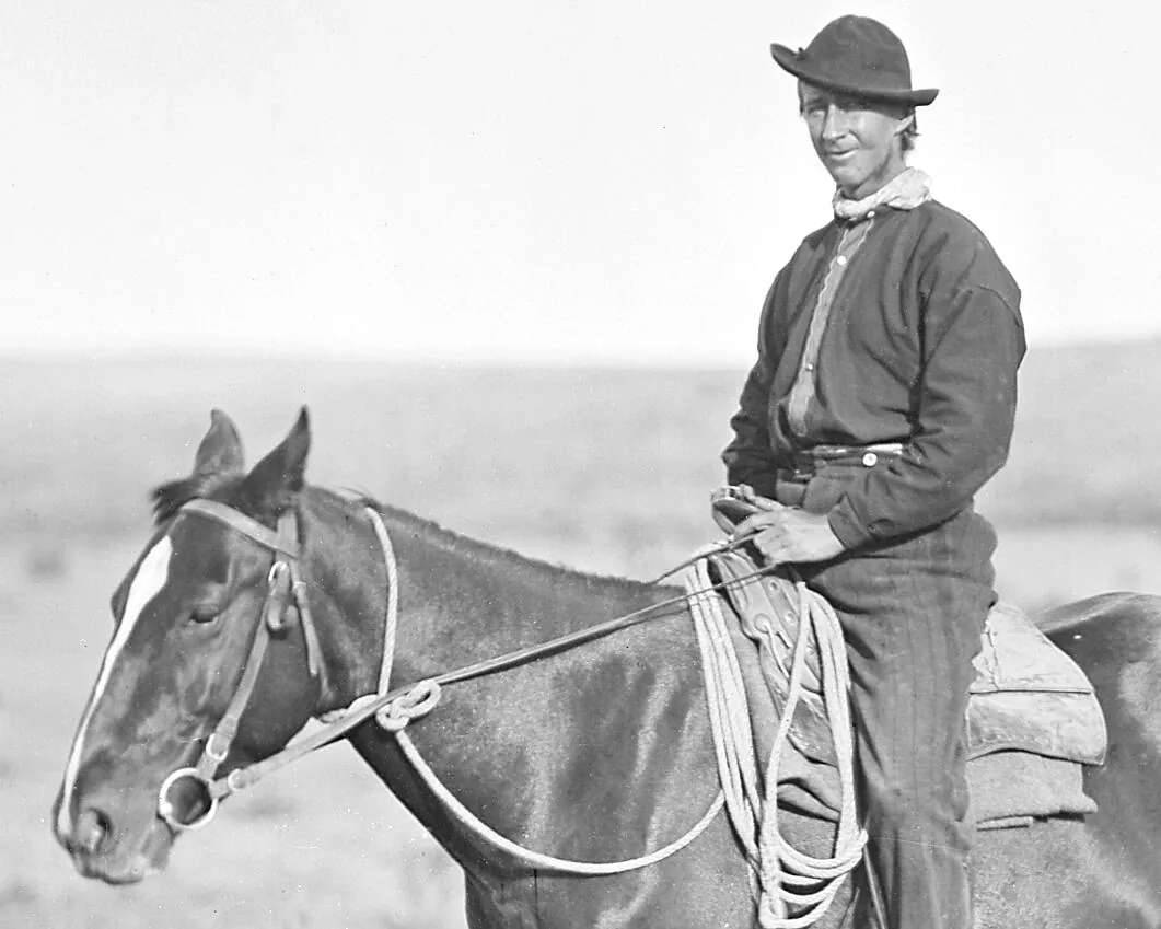
In the summer of 1871, Ferdinand Vandiveer Hayden led the first government-funded scientific survey of the Yellowstone region. With a $40,000 congressional appropriation — a massive sum at the time — Hayden assembled a team of 34 men including geologists, botanists, a meteorologist, a topographer, the painter Thomas Moran, and the photographer William Henry Jackson.
The expedition spent two months in Yellowstone, systematically documenting every major feature. They collected mineral specimens, mapped hot spring temperatures, measured geyser eruption intervals, cataloged plant and animal species, and produced the first reliable topographic maps of the region.
What made the Hayden Survey different from every previous expedition was its dual weapon: science and art. Previous explorers had brought back words. Hayden brought back proof — in the form of Jackson's photographs and Moran's watercolor sketches.
Hayden's 500-page report to Congress, combined with Jackson's photographs and Moran's artwork, became the most persuasive argument for preservation ever assembled. Within months, Congress passed the Yellowstone National Park Protection Act. To understand how the railroad industry also played a role in the park's creation, read our companion article.
Thomas Moran — Art That Changed a Nation
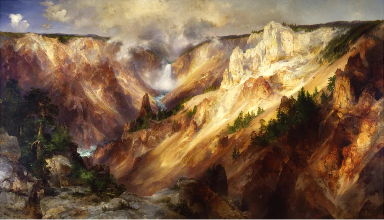
Thomas Moran was a 34-year-old English-born artist when he joined the Hayden Survey. He had never been west of the Mississippi, and he almost didn't go — he had to borrow money for the trip, with Scribner's Monthly advancing him $500 in exchange for sketches to illustrate Langford's articles.
What Moran saw at the Grand Canyon of the Yellowstone transformed him — and American art. His watercolor field sketches captured colors that Jackson's black-and-white photographs could not: the sulfurous yellows, the iron reds, the impossible blues of the Yellowstone River cutting through its canyon. He later transformed these sketches into a massive 7-by-12-foot oil painting, The Grand Canyon of the Yellowstone.
Congress purchased the painting for $10,000 — an unprecedented sum for an American landscape painting — and hung it in the U.S. Capitol. It became the single most influential artwork in the history of American conservation. Representatives who had never traveled west could see, for the first time, what Yellowstone actually looked like.
Today, Moran's viewpoint at Artist Point remains one of the most visited spots in the park. To visit it yourself, see our Yellowstone Day Hikes guide for trail details, and explore our Best Sunrise & Sunset Spots guide — Artist Point at golden hour is unforgettable.
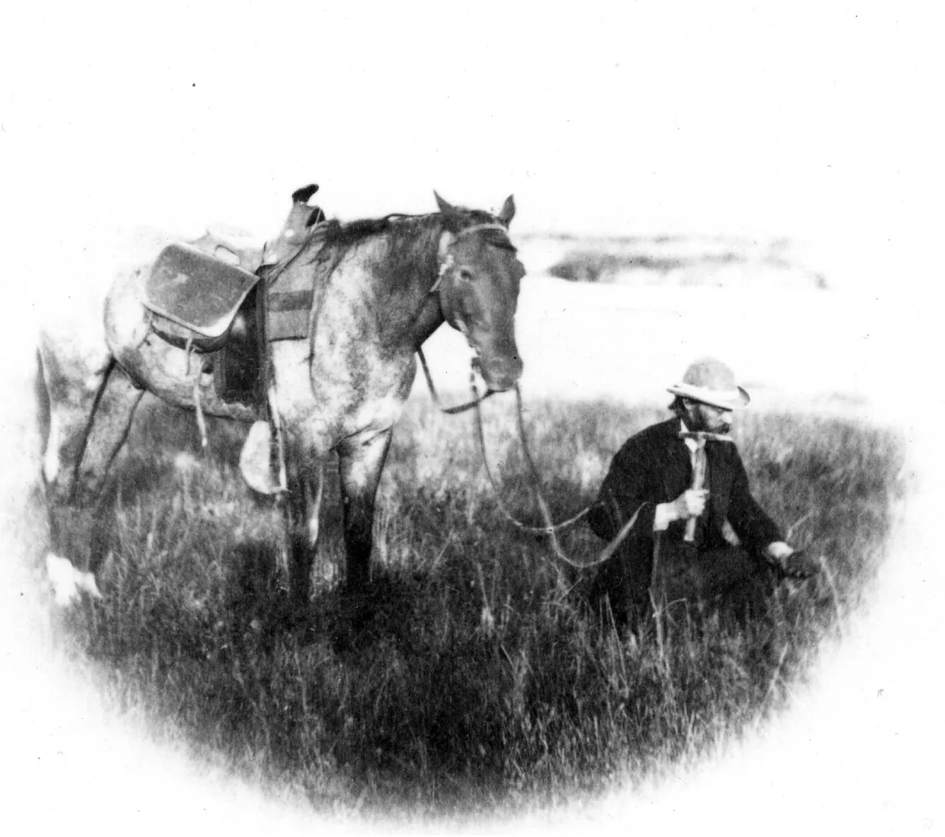
William Henry Jackson — Photography as Proof
William Henry Jackson was 28 when he joined the Hayden Survey as the official photographer. Working with the wet-plate collodion process — a painstaking technique that required coating glass plates with chemicals in a portable darkroom, exposing them while still wet, and developing them immediately — Jackson produced photographs under conditions that would challenge modern professionals.
His equipment weighed over 300 pounds. Every photograph required hauling a fragile glass plate, a portable darkroom tent, bottles of chemicals, and a large-format camera up mountain trails and across geyser basins. Many plates cracked. Chemicals froze. Wind blew the tent over.
Despite these challenges, Jackson produced the first photographs of Yellowstone's major features: Old Faithful, the Grand Canyon, Mammoth Hot Springs, Tower Fall, and Yellowstone Lake. These images were the first visual evidence that the trappers' stories were true.
Hayden distributed Jackson's photographs to every member of Congress before the park bill vote. The images were so compelling that several senators later stated they were the deciding factor in their support.
Jackson went on to photograph Mesa Verde, the Tetons, and other Western landmarks. His Yellowstone photographs are preserved in the National Archives and remain among the most important documents in American conservation history. Many of the views he captured can still be seen today — check our Bison Guide for Hayden Valley, named after the expedition leader himself.
Scientific Discoveries That Amazed the World
The Hayden Survey wasn't just a sightseeing trip — it was rigorous science. The team's discoveries reshaped understanding of geology, hydrology, and biology:
- Geothermal mapping: The survey documented over 10,000 hydrothermal features — the largest concentration on Earth.
- Petrified forests: Multiple layers of petrified trees on Specimen Ridge — evidence of successive volcanic eruptions over millions of years.
- Obsidian Cliff: Confirmed Jim Bridger's "mountain of glass" — quarried by Native peoples for at least 11,000 years.
- The Grand Canyon: A 20-mile canyon with kaleidoscope colors caused by iron compounds oxidizing in rhyolite rock.
- Hot spring microbiology: First observations of thermophilic extremophiles — organisms that eventually led to the invention of PCR technology.
For more on the volcanic forces behind these features, read our deep-dive on the Yellowstone Supervolcano.
The Road to Protection
By the fall of 1871, Hayden had assembled the most compelling case for land preservation in American history. His strategy was deliberate and multi-pronged:
- The scientific report: A 500-page document proving the region's features were unique on Earth.
- The photographs: Jackson's prints distributed to every member of Congress.
- The artwork: Moran's watercolors displayed in the Capitol.
- The lecture circuit: Langford's and Hayden's presentations to scientific societies and political leaders.
- Railroad support: The Northern Pacific Railroad lobbied heavily, seeing a tourist destination that would fill their trains.
On December 18, 1871, a bill was introduced in Congress to set aside the Yellowstone region as a public park. On March 1, 1872, President Ulysses S. Grant signed the Yellowstone National Park Protection Act into law.
For the full story of this legislative battle, see our Creation of Yellowstone National Park article. And to understand the railroad's commercial motivations, read Railroad Tourism in Yellowstone.
Legacy of the Explorers
The explorers of Yellowstone didn't just discover a landscape — they invented the idea that a landscape could belong to everyone. Before 1872, the concept of a "national park" didn't exist anywhere in the world.
Their names are written across the map of Yellowstone today:
- Hayden Valley — the wide, wildlife-rich valley named for Ferdinand Hayden
- Mount Washburn — named for Henry Dana Washburn, offering the best panoramic views in the park
- Langford Hot Springs — named for Nathaniel Langford, the park's first superintendent
- Moran Point — Thomas Moran's Grand Canyon viewpoint
- Bridger Range — mountains north of Yellowstone named for Jim Bridger
- Doane Peak — named for Lieutenant Gustavus Doane
But the most important legacy wasn't a mountain or a valley — it was an idea. Yellowstone proved that a democratic nation could set aside its most extraordinary places for the common good. That idea spread to every continent, and today there are over 4,000 national parks in more than 100 countries. The next chapter involved the U.S. Army taking over management of the young park.
Walk in Their Footsteps
You can still visit the exact places these explorers documented. The views from Artist Point, Tower Fall, and Old Faithful look almost unchanged from Jackson's photographs and Moran's paintings 150 years ago.
Must-See Explorer Sites
- → Artist Point — Moran's famous viewpoint
- → Obsidian Cliff — Bridger's "mountain of glass"
- → Old Faithful — named by the Washburn expedition
- → Hayden Valley — the survey leader's namesake
- → Mount Washburn summit trail
Plan Your Trip
Our cabin at Lodgepole Pines Retreat in Island Park is just 30 minutes from Yellowstone's West Entrance — the same route early explorers followed along the Madison River into the park. Book directly and save up to 10%.